Discover the heartbeat of India through its iconic Golden Triangle – where whispers of history and thrills unfold at every turn of the road.
Why the Map of India Golden Triangle Captivates Travelers Worldwide
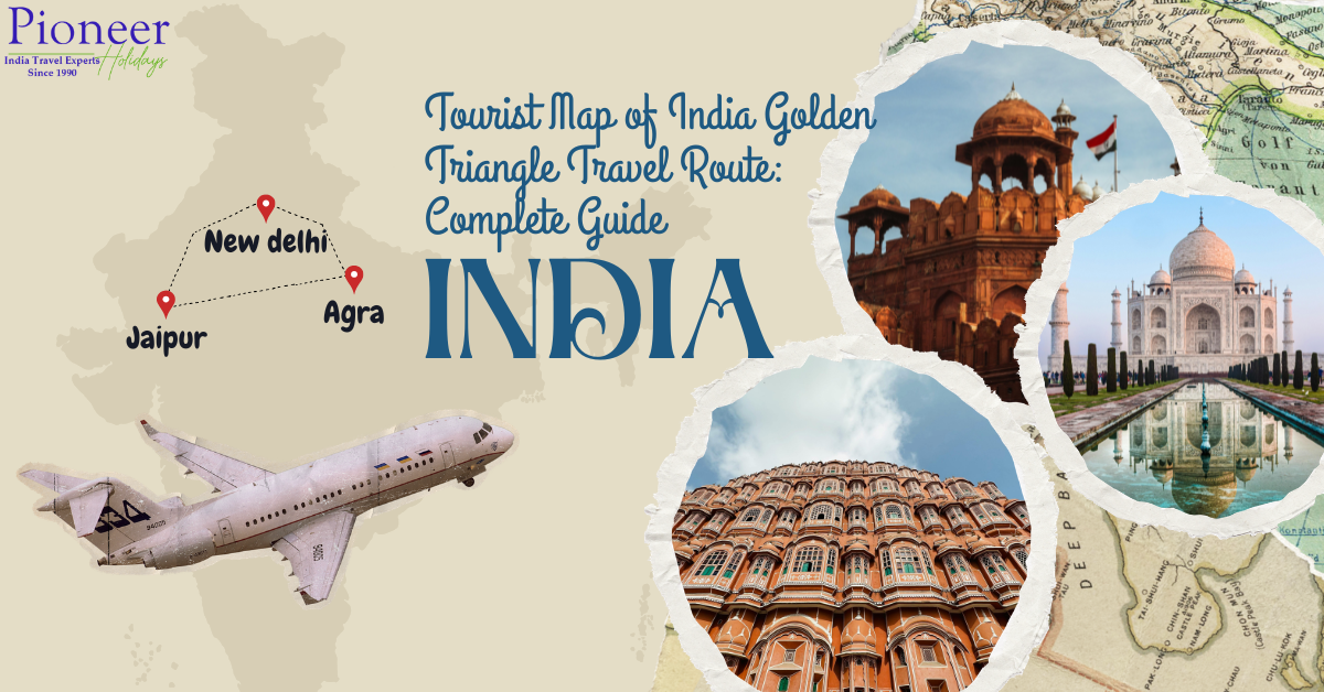
Imagine discovering ancient empires, majestic forts and timeless wonders in a brief loop that packs the soul of India into one unforgettable journey. The Golden Triangle map of India shows a mesmerizing route connecting Delhi, Agra and Jaipur – these three gems form the center of India’s most famous tourist circuit.
This triangle, spanning only 720 kilometres, is not just a route; It is the gateway to Mughal grandeur, Rajput valor and vibrant markets. Travelers come here for the seamless blend of chaos and culture, where modern metropolis meets medieval wonders. Whether you’re a history buff or planning your dream trip for the first time, the India Tourism Map makes Golden Triangle exploration simple.
This guide dives deep into every turn, and helps you navigate like a pro. From hidden trails to must-see stops, we’ve mapped it all for an immersive adventure.
Decoding the Tourist Map of India Golden Triangle: Key Cities and Connections
At its heart, the tourist map of India Golden Triangle highlights three powerhouse destinations:
- Delhi: The bustling capital, gateway to the north.
- Agra: Home to the Taj Mahal’s ethereal beauty.
- Jaipur: The pink city’s royal opulence.
These centers are connected via well-paved highways – NH48 from Delhi to Jaipur (260 km), NH21 to Agra (230 km), and back via Yamuna Expressway (200 km). Trains like Shatabdi Express reduce road travel hours, while domestic flights connect airports faster.
| Segment | Distance | By Road (Time) | By Train (Time) | Highlights |
|---|---|---|---|---|
| Delhi to Agra | 230 km | 3-4 hours | 1.5-2 hours | Taj views at dusk |
| Agra to Jaipur | 240 km | 4-5 hours | 3-4 hours | Fatehpur Sikri en route |
| Jaipur to Delhi | 260 km | 4-5 hours | 4 hours | Amber Fort vistas |
Pro Tip: Download an interactive map of India Golden Triangle app like Google Maps, Bharat Maps or Maps.me for offline navigation – essential to avoid rush hour jams.
Crafting Your Perfect 7-Day Itinerary Using the Map of India Golden Triangle
A standard Golden Triangle trip is completed in 7 days, looping clockwise or counterclockwise. Start in Delhi to acclimatise, then head south to the wonders of Agra and east to the forts of Jaipur. Here’s a day-by-day outline taken straight from India’s tourist map, the Golden Triangle.
Day 1-2: Delhi – The Vibrant Starting Point
Land at Indira Gandhi International Airport and take to the labyrinthine streets of Old Delhi. Humayun’s Tomb sets a Mughal tone, while the spice markets of Chandni Chowk are buzzing with life. Cycle rickshaws navigate narrow streets better than cars.
Key stops:
- Red Fort: Echoes of emperors past.
- Jama Masjid: Climb minarets for panoramic views.
- Lotus Temple: Serenity amid urban frenzy.
Pro tip: Sunset at India Gate feels like stepping into a living postcard.
Day 3: Agra Bound – Crossing the Yamuna
As soon as the gate opens, a dawn drive on the Yamuna Expressway takes you to the Taj Mahal. This marble masterpiece, built by Shah Jahan, changes color with the sun – pink at sunrise, golden at dusk.
Afternoon: Agra Fort’s red sandstone ramparts overlook the Yamuna River.
Day 4: Agra’s Hidden Gems and Fatehpur Sikri Detour
Explore Mehtab Bagh for reflections of the Taj, then take a 40km detour to Fatehpur Sikri – Akbar’s abandoned ghost town with intricate carvings. The Golden Triangle map of India shines here, showing unique routes among tourist trails.
Day 5-6: Jaipur – Pink City Majesty
Reaching via NH21, one will be greeted by the honeycomb facade of Hawa Mahal. The Amber Fort demands an elephant climb (or jeep for the ethical), its mirror-worked halls dazzling under the lights.
Jaipur’s itinerary bursts with:
- City Palace: Royal artifacts and peacocks.
- Jantar Mantar: World’s largest stone observatory.
- Nahargarh Fort: Twilight city overlooks.
Jaipur’s bazaars tempt with block-printed textiles that scream ‘take me home!’
Day 7: Return to Delhi with a Twist
If wildlife calls, stop at Sariska Tiger Reserve and return via NH48 (2 hours detour). Consider your route as the Delhi skyline welcomes you.
Interactive Map of India Golden Triangle: Tools for Seamless Navigation
Gone are the days of paper maps – digital versions enhance your journey. India’s Tourism Map Golden Triangle Thrives Online:
- Google Maps: Custom layers for traffic, monuments, and eateries.
- Bharat Maps: Government-backed for precise highway intel.
- Offline Apps: OsmAnd or Maps.me with pre-loaded Golden Triangle overlays.
Print a simplified version too:
Delhi ──────(260 km)────── Jaipur
│ │
(230 km) (240 km)
│ │
└───────── Agra ──────────────┘
Visit additional locations like Ranthambore (south of Jaipur) for tiger safaris or Keoladeo National Park near Agra for bird watching.
Best Seasons to Trace the Map of India Golden Triangle
Time unlocks the magic. Winter (October–March) has cool 15–25 °C days – ideal for climbing the fort. Monsoon (July-September) brings lush greenery but there is a risk of floods. Avoid temperatures above 40°C in summer.
| Season | Weather | Pros | Cons |
|---|---|---|---|
| Winter | Cool, dry | Festivals like Diwali | Crowds peak |
| Monsoon | Lush, rainy | Fewer tourists | Slippery roads |
| Summer | Hot, dusty | Low crowds | Intense heat |
Winter’s crisp air makes every palace step feel epic.
Road Trip Hacks Along the Tourist Map of India Golden Triangle
Self drive? Rent a sturdy SUV for potholed stretches. The highways gleam, but rural connections demand caution.
Safety essentials:
- Carry ID, water, snacks.
- Use toll apps like FASTag.
- Fuel up in cities—stations sparse en route.
Public transport shines: AC buses from UPSRTC or luxury trains like Palace on Wheels for rail enthusiasts.
Cultural Detours Off the Map of India Golden Triangle
Venture beyond the triangle for depth. Add:
- Vrindavan (near Agra): Krishna temples alive with chants.
- Pushkar (near Jaipur): Sacred lake and camel fair vibes.
- Mathura: Birthplace lore and colorful ghats.
These extensions expand your Golden Triangle of India tourist map into a cultural tapestry without impacting the original loop.
Food Trail Mapping the Golden Triangle
Shows the diversity of food routes. Paranthas of Delhi give energy in the morning, Petha sweets of Agra make delicious, Dal Bati Churma of Jaipur gives satisfaction.
Must-try stops:
- Karim’s (Delhi): Mutton korma mastery.
- Panchhi Petha (Agra): Sweet silk.
- Laxmi Mishtan (Jaipur): Ghevar delights.
Vegetarian? Street chaat carts everywhere—hygiene first!

Photography Hotspots on the Tourist Map of India Golden Triangle
Capture Instagram gold:
- Taj at dawn (no crowds).
- Amber Fort’s light shows.
- Delhi’s street life chaos.
Frame the Taj’s symmetry against misty Yamuna—pure poetry.
Use wide-angle lenses for forts; drones restricted near monuments.
Sustainable Travel on the Map of India Golden Triangle
Tread carefully: opt for eco-lodges, avoid single-use plastics. Support local artisans in Jaipur markets. Choose trains instead of flights to cut emissions.
Common Pitfalls and Pro Tips from the Tourist Map of India Golden Triangle
Avoid:
- Weekends at Taj (lines snake).
- Ignoring monsoon roadblocks.
- Forgetting sunrise slots
Wins:
- Book monuments online.
- Hire local guides for stories.
- Pack light layers.
Conclusion: Your Gateway to India’s Timeless Loop Awaits
The Golden Triangle Map of India is not just lines on paper – it is an invitation to live the legends of India. From the electric pulse of Delhi to the romantic allure of Agra and the royal charm of Jaipur, this route weaves history, hustle and heart into one epic story. Whether alone or with loved ones, it promises changes that last long after the trip is over.
Are you ready to make your way? Pin this tourist map of India’s Golden Triangle, pack your wanderlust, and let the adventure unfold.
Frequently Asked Question
What is the map of India Golden Triangle?
It’s a triangular route linking Delhi, Agra, and Jaipur, showcasing India’s top heritage sites in a 720 km loop—perfect for 7-day escapes.
How long does the tourist map of India Golden Triangle take to complete?
Typically 7 days by road or train, with flexible extensions for side trips.
Best way to travel the map of India Golden Triangle?
Mix trains for speed (Shatabdi) and private cars for flexibility—highways are modern and scenic.
Can I customize the tourist map of India Golden Triangle?
Absolutely—add wildlife parks or spiritual sites like Pushkar for a personalized spin.
Is the map of India Golden Triangle family-friendly?
Yes, with kid-approved forts, elephant rides, and light walks—opt for winter for comfort.
Peak season for the tourist map of India Golden Triangle?
October to March, when festivals amplify the magic without summer’s swelter.
You May Like – Golden Triangle Tour Packages